



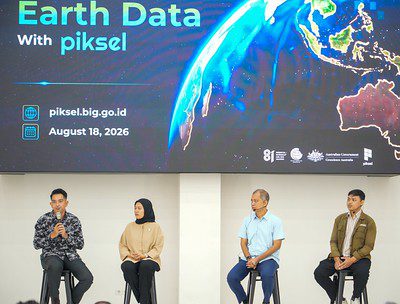
MATRAS ENGLISH – Badan Informasi Geospasial (BIG) with support from Geoscience Australia (GA), has launched Piksel, a sovereign earth observation analysis platform that will strengthen Indonesia’s ability to map, monitor and sustainably manage its marine and coastal environments.
Developed under the 2025 Memorandum of Understanding between BIG and GA, Piksel was delivered through Australia’s Southeast Asia Maritime Partnerships and bilateral maritime cooperation, which in turn enables BIG to support a range of Indonesian maritime agencies.
“The challenge lies not merely in acquiring the data. The far greater challenge is processing such vast amounts of data into useful information quickly, efficiently, and in a way that makes it accessible to a broader range of stakeholders,” said the Acting Head of BIG, Mohamad Arief Syafi’i, in his remarks.
As natural maritime partners, Australia and Indonesia are working together to support Indonesia’s coastal communities, promote a sustainable blue economy, and address shared challenges in marine resource management.
“Piksel will allow Indonesian officials and researchers to perform national scale analysis of the environment to produce impactful and cost-efficient mapping products from satellite imagery,” said Lauren Power, A/g Oceans, Reefs, Coasts and the Antarctic Branch Head, Geoscience Australia.
“Piksel can be used to develop coastal and marine mapping products such as Ina Coastlines that provide the foundational geospatial data required for effective marine resource management and marine spatial planning,” she added.
The launch of Piksel reflects the growing maritime partnership between Australia and Indonesia. As President Prabowo and Prime Minister Albanese announced in May 2025, Indonesia and Australia are increasing our maritime cooperation to support a peaceful, stable and prosperous region.









Komentar ditutup.